A GeoTIFF Map Editor That Runs Online and Keeps Your Imagery Private
August 4, 2026
You have a georeferenced raster. The orthophoto from yesterday’s flight, a scanned survey sheet from a national archive, a satellite chip that came down with the tasking. Today the ways to work with it are bad in three different directions: desktop GIS opens it after an install and a learning curve, a cloud platform opens it after you hand your imagery to somebody else’s servers, and a free web viewer opens it and then does nothing at all. Look at the pixels, close the tab.
MapGridder now opens a GeoTIFF directly on the map. The file is read on your device, it places itself from the georeferencing baked into it, and everything the app already does is waiting on top: MGRS and metric grids, tactical symbols, measurements, routes, and a paper-sized export. Your imagery becomes a gridded map, and the pixels never leave your machine.
Drop a GeoTIFF on the map and watch it land on its own coordinates.
Open a GeoTIFF on the mapWhat happens when you import one
Add the file the way you add any reference image. It is decoded on your device, the georeferencing inside it is converted into four corners on the real world, and the imagery appears there. The map moves to meet it. Nothing is dragged, scaled, or eyeballed into position.
Two details are worth knowing, because they are where most tools give up. If the survey was not flown square to north, the rotation recorded in the file is honored rather than flattened into an upright rectangle. And the empty collar around a flight area, the part that is not really data, comes in transparent, so the orthophoto sits on the basemap instead of inside a black frame.
From that moment it is an ordinary overlay: fade it to see the basemap through it, hide it, reorder it, and draw whatever you like above it. Here is the slice of the format that opens:
- Coordinate systems: lat/long (WGS 84), Web Mercator, and every UTM zone. That last one matters most: drone mapping software writes the local UTM zone by default, and US federal orthoimagery arrives the same way.
- Imagery: color and greyscale, palette-color map scans, and 16-bit satellite products stretched to something you can actually see.
- Big files: tiled rasters open from their embedded overview levels, so a very large sheet appears in seconds instead of decoding at full resolution. The ceiling is 25 MB per file.
- Everything else: refused by name. A file in an unsupported coordinate system tells you which system it uses and what to re-export it as, which beats imagery quietly landing two hundred meters off. A plain TIFF with no georeferencing at all is not an error either: it lands at the map center for hand anchoring, exactly like a photo.
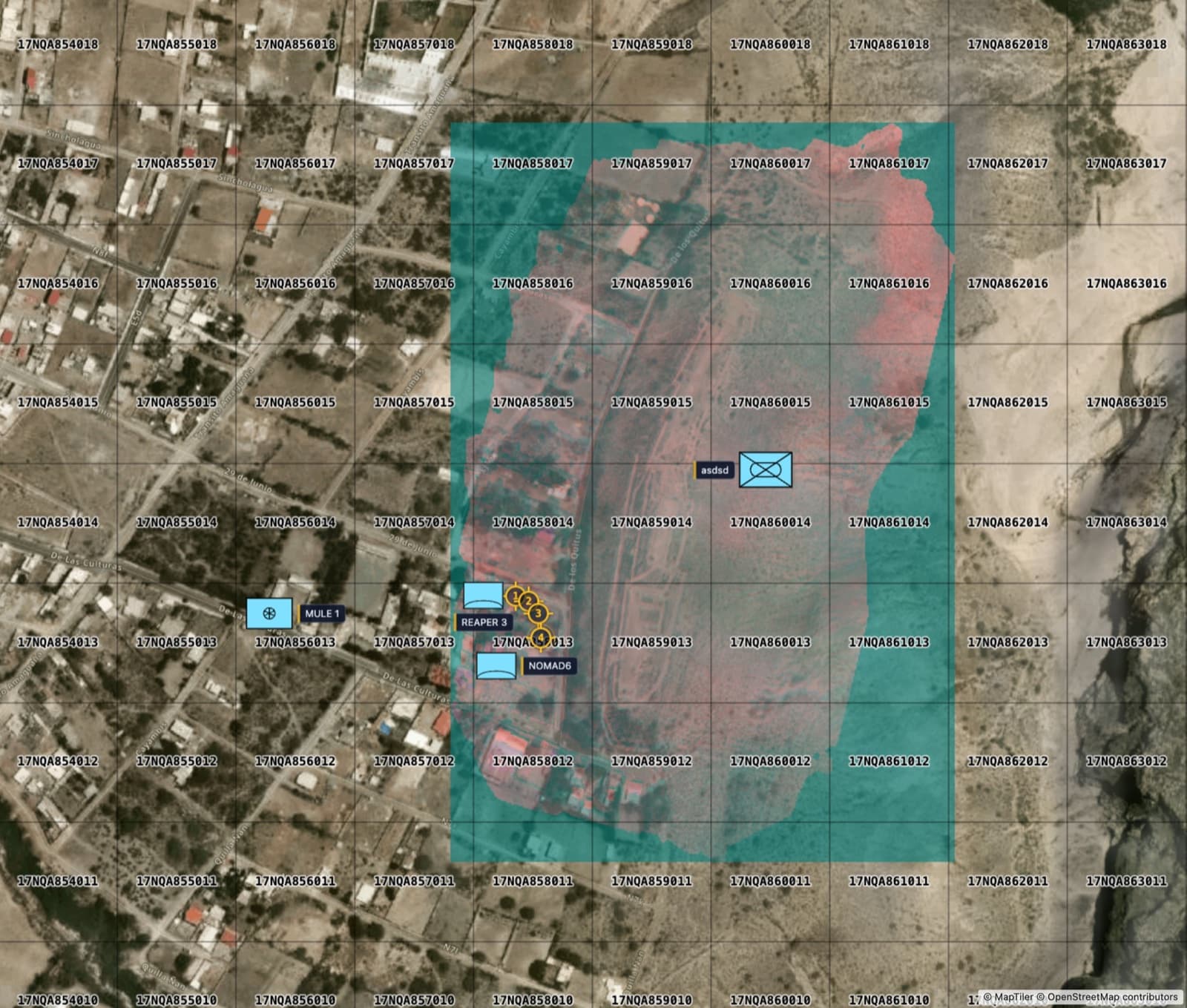
Operators: yesterday’s flight, today’s briefing sheet
Basemap imagery is months or years old. The orthophoto you flew yesterday shows the vehicle tracks, the new berm, the vegetation as it stands this week. Bring it in, turn on MGRS, and that imagery becomes addressable: every feature on it carries a grid reference that a radio, a paper map, and a handheld GPS all agree on. Put unit symbols and control measures where they belong, measure the approach, and hand out a sheet at a real scale instead of a screenshot.
It is the same planning loop you already run, over your own imagery instead of somebody else’s tiles. Export it as a paper map at true scale when the plan is ready.
Milsim organizers: the actual site, not a sketch of it
Site maps for an airsoft or milsim event are usually a hand drawing or a screenshot with squares painted over it, and both fall apart the moment two squads describe the same treeline differently. A morning of flying gives you the real site, and under a real grid it turns into the reference everyone briefs from: objectives numbered, boundaries drawn, respawns marked, one sheet per element.
Because the grid is a genuine coordinate system rather than painted lines, a square called over the radio matches what a GPS shows in the field. See how the rest of the kit fits together on the milsim map planning page.
Analysts: open the raster where the work already happens
Looking at a raster usually costs you something first: install desktop GIS and learn it, or push the file into a platform and wait on the approval chain that any upload of source imagery triggers. Opening it in a browser tab removes both. The file is read locally, so there is no transfer to justify and nothing to request.
Once it is on the map it is not a picture in a viewer. Measure across it, trace features, read any point in the grid your report is written in, and take the vector work back out in a format other tools read: export what you drew as GeoJSON.
Private by design
The decoding happens in your browser. The pixels are read from the file on your device, drawn onto your map, and kept in your browser so the overlay is still there next time you open it. They are not sent to us. When you save a map, the position the imagery occupies travels with it; the imagery itself stays where it started.
For most people that is a pleasant property. For some it is the entire decision. Imagery that cannot be uploaded is imagery that cannot be worked on in a web tool, which is exactly why so much of this work is still done on a laptop under a desk. Reading the file locally removes the conflict instead of asking anyone to make an exception.
Organizations that need this inside their own network, air-gapped or behind their own controls, and with a commercial license to match, can run MapGridder on their own infrastructure. The same holds for imagery heavier than the browser limit, or imagery that lives in your own storage.
Working with imagery that cannot leave your network? Tell us what you are holding and we will tell you what it takes.
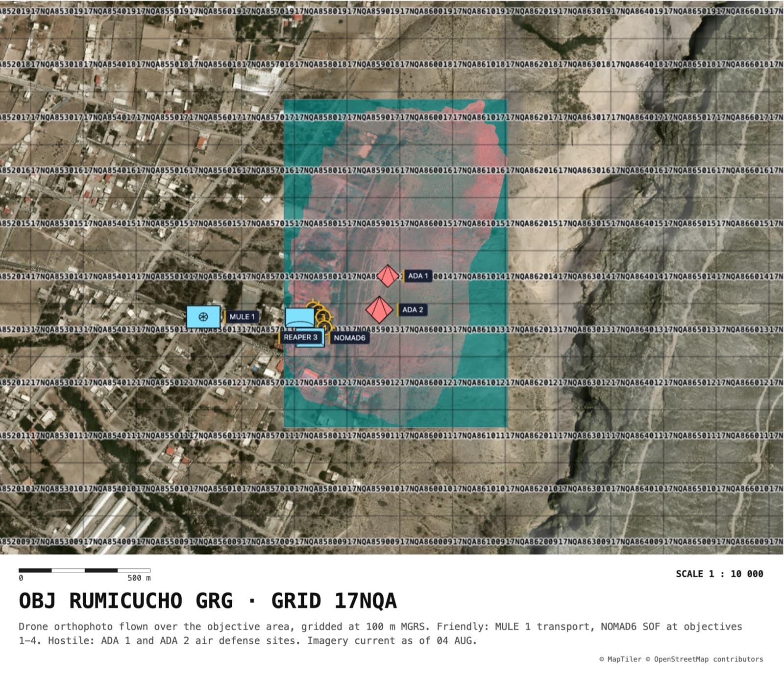
Import a GeoTIFF, step by step
- Open the map and choose File → Overlay / GRG, then Upload file.
- Pick your .tif or .tiff. It decodes on your device and lands on its own coordinates.
- Lower the opacity if you want the basemap showing through, and raise it again once you have checked the fit.
- Turn on the grid you brief from: MGRS, UTM, lat/long, or a custom metric grid with row and column labels.
- Work on top of the imagery: symbols, drawings, waypoints, measurements, routes.
- Capture the screen, or use Export as Map for a titled image or a paper-sized PDF at a true scale. Export needs a free account.
Frequently asked questions
Which GeoTIFF files can MapGridder open?
Files georeferenced in lat/long (WGS 84), Web Mercator, or any UTM zone, which covers most drone orthophotos, satellite chips, and government imagery. Color, greyscale, palette-color scans, and 16-bit imagery all open, along with the common compressions and tiled files, up to 25 MB. A file in some other coordinate system is refused by name: you are told which system the file uses and what to re-export it as, instead of getting imagery placed a few hundred meters off.
Does my imagery get uploaded anywhere?
No. The file is read on your device and the pixels stay there. The overlay is stored in your browser so the imagery is still on the map when you come back, and nothing about it is sent to a server.
Do I need to reproject a drone orthophoto first?
No. Drone mapping software writes the local UTM zone by default, and those files import directly. Converting to lat/long first is unnecessary and costs you a resampling pass over the pixels.
What happens if the TIFF has no georeferencing?
It still opens. A plain TIFF lands in the middle of your current view and you anchor it by hand, the same way you would anchor a map scan or a screenshot.
Can I put an MGRS grid over my own imagery and export it?
Yes. A georeferenced image is tied to the real map, so any grid renders across it correctly: MGRS, UTM, lat/long, or a custom metric grid with row and column labels. Export produces an image or a paper-sized PDF at a true cartographic scale with the imagery, the grid, and your annotations baked in. Export needs a free account. Personal and non-commercial use is free; commercial use needs a paid license.
How large a file can I import?
Up to 25 MB, and large tiled rasters open from their embedded overview levels rather than grinding through full resolution. Heavier imagery, imagery streamed from your own storage, and running all of this inside your own network are on-prem territory. Write to help@mapgridder.com and describe what you are holding.
Have a raster sitting in a folder because opening it was too much trouble? Put it on the map, give it a grid, and see what it looks like as a working sheet.