Security Site Plan Map: Zones and Sectors
September 13, 2026
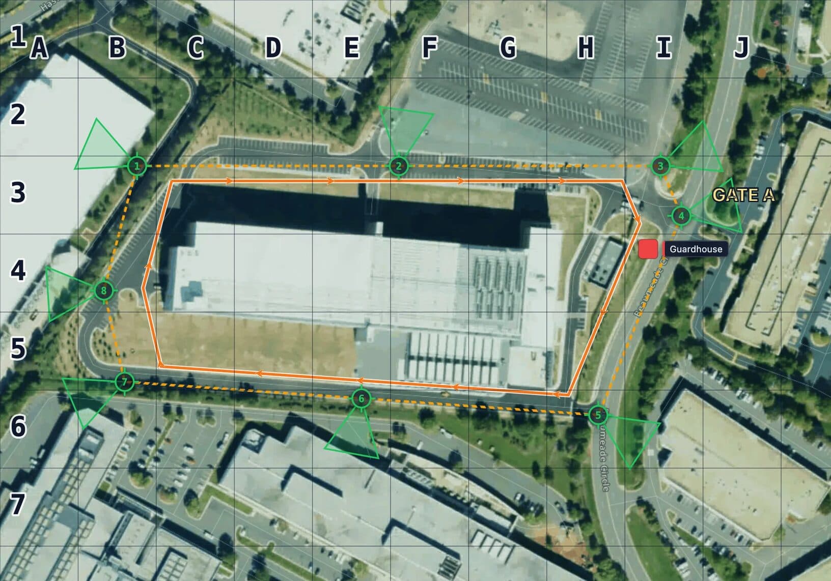
A security site plan map is a scaled map of a venue, site or event footprint that shows the perimeter zones, a lettered grid for radio calls, the numbered posts, the sectors each team owns and the standoff distances from the points that matter. Security managers use it for briefings, guarding post orders, risk assessment reports and the documentation regulators ask for.
In this guide
- Draw the zones on satellite imagery in the map editor: public, outer, inner.
- Put a lettered grid over the venue so a radio call names a cell, not a landmark.
- Number the posts, place medical and control, split the footprint into sectors.
- Add closure points along a route and standoff rings from a published distance.
- Export a PDF at true scale for the briefing pack and share a read-only link with stewards and partner agencies.
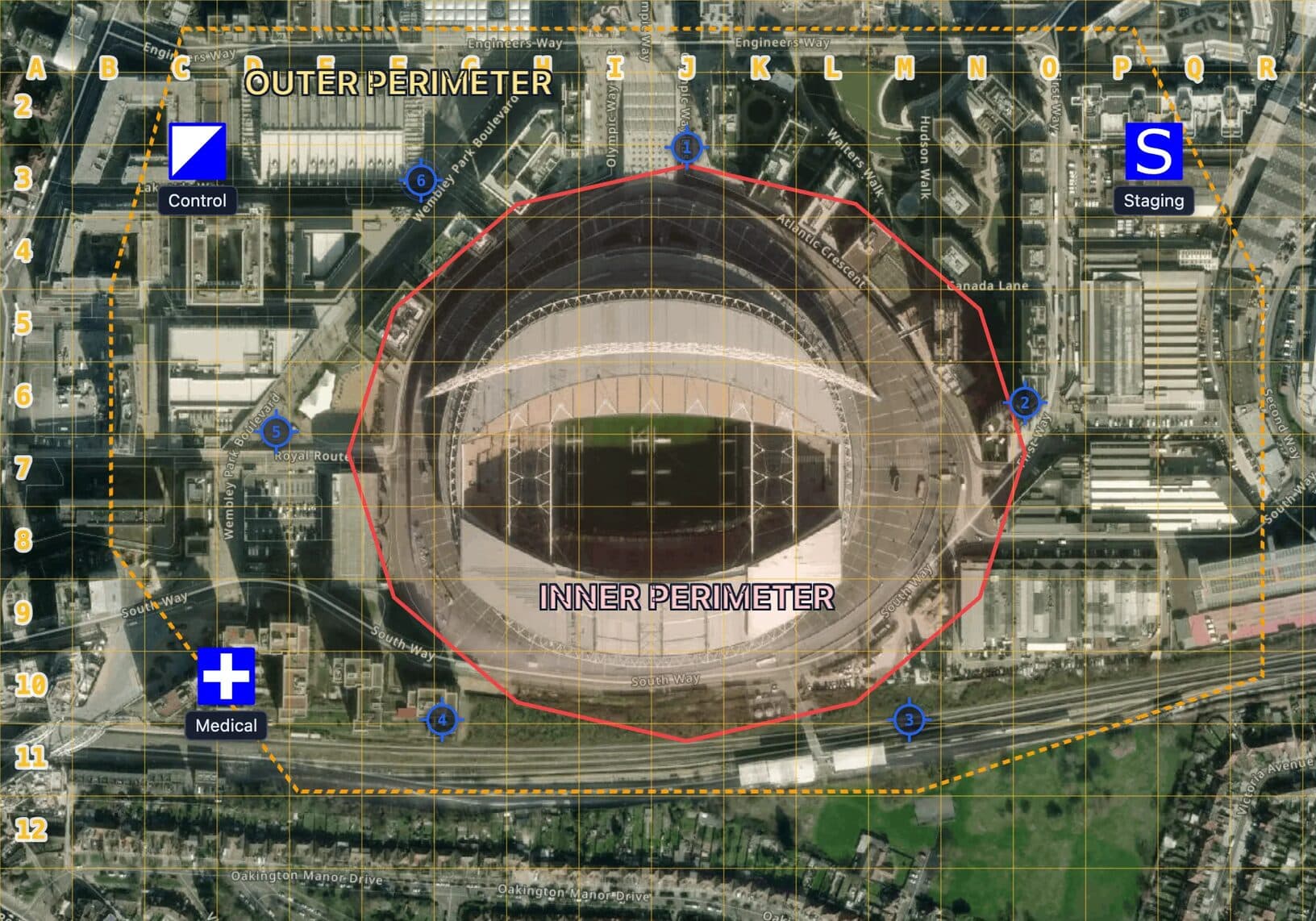
A lettered grid so a radio call names a cell
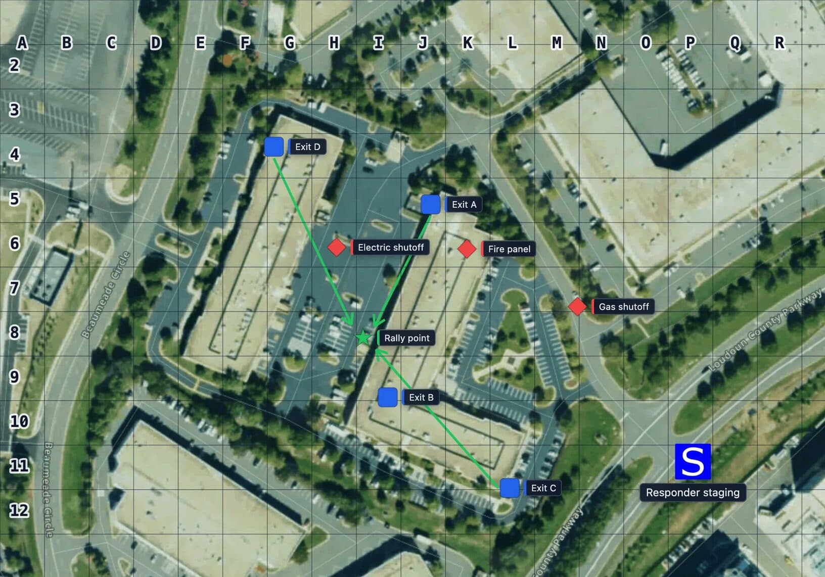
The most useful thing on a venue security site plan is a grid with column letters and row numbers. "Medical to M11" is unambiguous on a radio in a way "by the south turnstiles, left of the burger van" never is. Set a custom grid in metres and pick a cell size that matches the job: 50 metres for a stadium footprint, 25 metres when a single cell should be one queue lane, 100 metres for a greenfield festival. The letters and numbers print on every export, so the radio room, the stewards and the police control all read the same reference. When you work alongside military or law enforcement units that already speak MGRS or USNG, switch the grid to that standard instead and the same map carries their references. Grid basics are in the map grid references guide.
Bring the venue drawing in as a gridded reference graphic
Satellite imagery is enough for the streets, the car parks and the approaches. For the interior of the footprint you usually have something better: the venue's own site plan, a CAD export from facilities, last year's festival layout. Export it as a PNG or PDF, place it over the imagery and anchor it at two known corners, and the drawing sits in the right place at the right scale under the grid. That is a gridded reference graphic, the GRG that responder agencies build for critical sites, and it takes minutes rather than a procurement. The full walkthrough is in how to create a GRG overlay. A geospatial PDF or a GeoTIFF from the surveyor lands in place on its own. The image never leaves your browser.
Posts, control, medical and staging
Number the posts. Each click places the next number, so Post 1 to Post 6 go down in the order of the deployment sheet and the map matches the roster without retyping. Place the control room, the medical point, the staging area for the response team and the casualty collection point with the same incident symbols the emergency services use, so a mutual aid partner reads the map without a legend. Screening lanes, welfare points and vehicle gates take a waypoint with a short label. Every one of them now carries a grid reference automatically, which is what the post orders and the radio assignment sheet need.
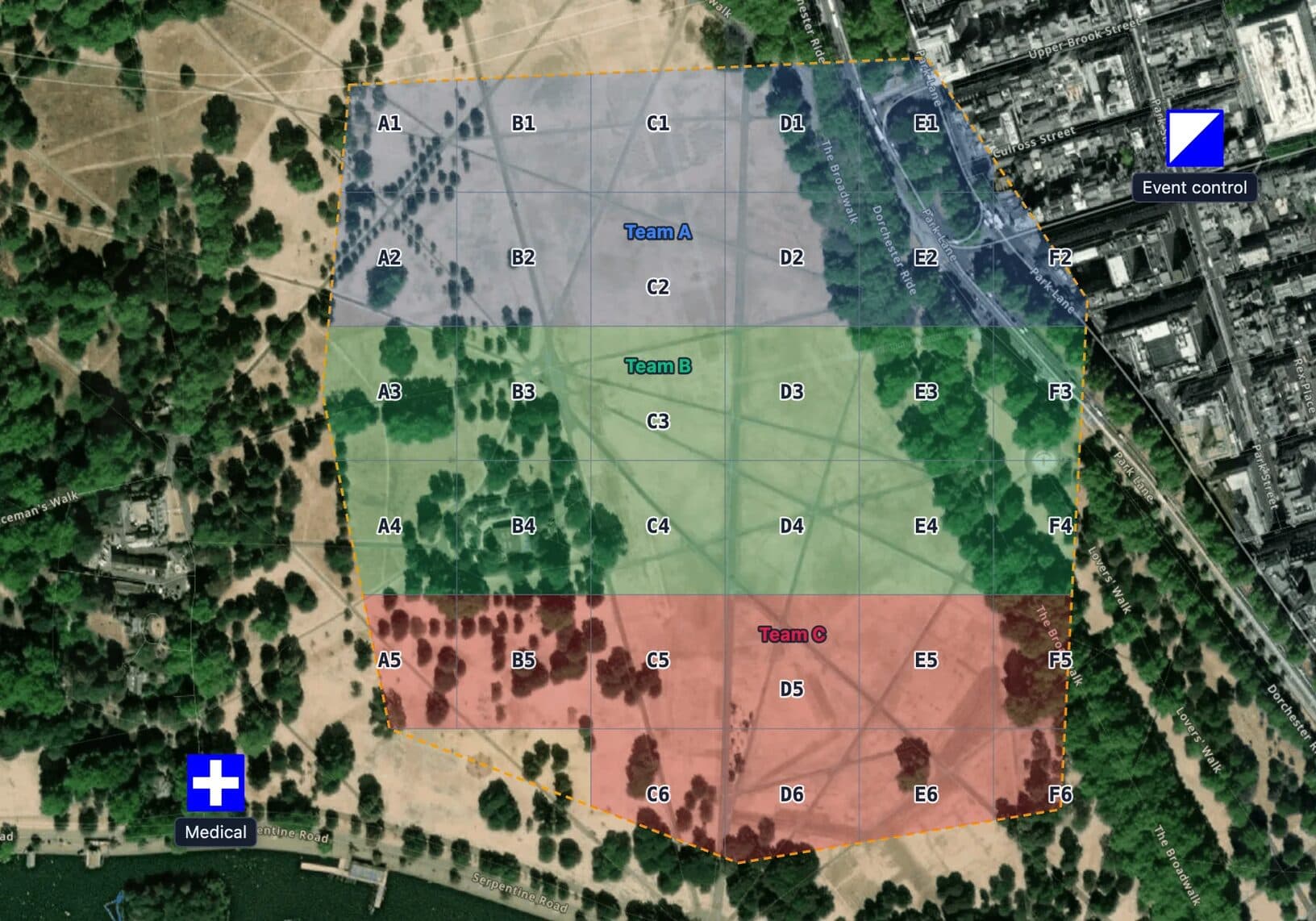
Split the footprint into sectors and hand each to a team
Crowd management zones are only useful once someone owns each one. Draw the footprint, split it into squares, and paint the squares that belong to each steward team in that team's colour. A camping field, a car park or a corporate site split into patrol beats per shift works the same way. The mechanics are the ones search teams use, described in how to divide an area into sectors.
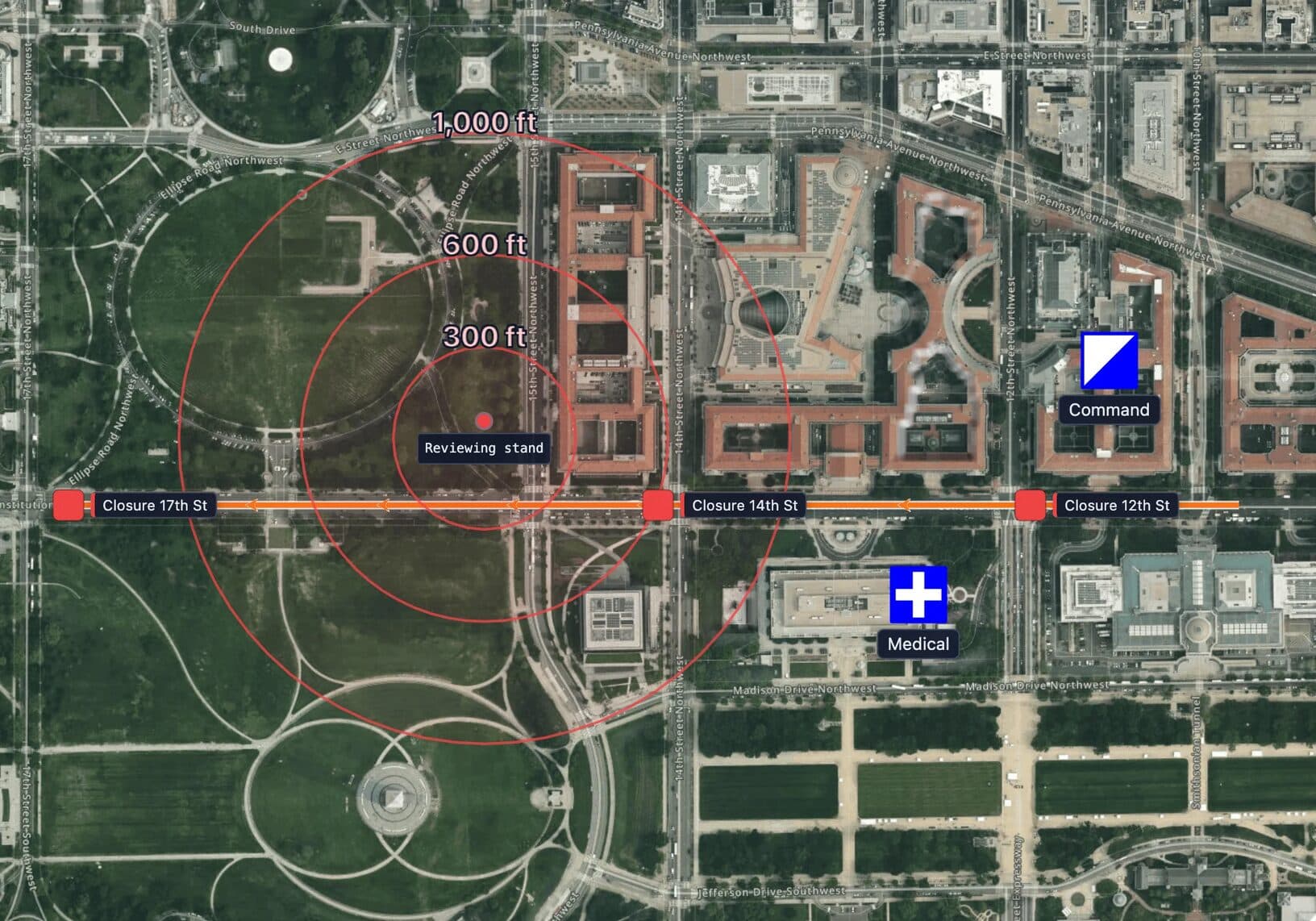
Routes, closures and standoff rings
A parade, a marathon or a motorcade is a line, not a footprint. Draw the route with direction arrows, drop a marker at every closure point and at the points where the route can be cut, and mark the command post and the medical point beside it. For an executive protection advance the same route tool carries the primary and two alternate routes with the timing waypoints, and a radius ring shows which trauma centre falls inside the drive you can accept.
Standoff is a distance from a point, and the point is where the crowd is thickest or the principal sits. Centre radius rings on the reviewing stand, the stage or the vehicle screening lane and the map shows which posts, queues and car parks fall inside each distance. Take the distances from a published source, not from memory: the DHS and DOJ bomb threat stand-off card hosted by CISA gives evacuation and shelter distances by device type. The tool draws the ring at any distance you supply. The card supplies the number.
Export the briefing pack and share it
The plan leaves the screen three ways. Print a PDF at a stated scale with the grid, the zones and every symbol on it for the briefing pack and the control room wall. Share a read-only link with the steward supervisors and the partner agencies; it opens in a phone browser, nothing to install, and nobody on the link can move a post. Hand the GeoJSON or a geospatial PDF to the police planning unit or the council GIS team, where every zone, post and sector arrives as a named feature. Next season, open the saved map, move what changed and export again. The footprint is the same. Only the date is new.
The same map across the security trade
- Event and venue security: the stadium and festival plans above, remade for every event on the same footprint, reviewed by the safety advisory group.
- Manned guarding: the patrol route map inside the post orders, with checkpoint order and numbered posts, printed for the site file and exported as an image for the guard tour app.
- Executive protection: the advance route card, primary and alternates, arrival and credential zones, safe room, and the ring to the nearest trauma centre.
- Corporate and critical infrastructure: layered perimeters, vehicle barrier lines and standoff rings for the physical security plan, then the same image dropped into the assessment report.
- Security consultants: the site diagram that goes into a risk assessment deliverable, on imagery the client recognises, rebuilt per engagement in an afternoon rather than redrawn by hand.
- Regulated premises: the outdoor half of a facility security plan for a port, a substation or a licensed cannabis site. Floor plans, camera schedules and surveyed school safety maps have their own accredited formats; this map is the site-level companion, not a substitute.
How this maps onto the Purple Guide and CISA guidance
The Purple Guide asks for a site plan with emergency routes and a crowd management plan built on capacity and flow. The zones, sectors and closure points are that plan in one picture. CISA venue guides and the mass gathering planning tool ask a venue to describe its perimeter, entry and traffic controls, and the exported map answers with a location for each. Use the guidance for what the plan must contain and the map for where each item sits.
The whole flow
- Open the venue on satellite imagery and overlay the site drawing if you have one.
- Set a custom grid in metres, sized to the footprint.
- Draw the outer and inner perimeter.
- Number the posts and place control, medical and staging.
- Split the footprint into sectors and paint a team onto each.
- Draw routes, closure points and standoff rings from a published distance.
- Export the PDF, share the link, save the map for next time.
FAQ
What is a security site plan map?
A scaled map of a venue, site or event footprint showing the perimeter zones, a lettered grid for radio calls, the numbered posts, the sectors each team owns and the standoff distances from the points that matter. Event plans, guarding post orders, risk assessments and regulator submissions all ask for the information on it; the map puts it in one picture.
How do I choose the grid cell size for a security site plan?
Match the cell to the smallest thing a radio call needs to name. 50 meters suits a stadium footprint and its approaches, 25 meters when one cell should be one queue lane or screening point, and 100 meters for a greenfield festival or a large car park. Keep the cell count low enough that letters and numbers stay readable on the printed page.
Is a security site plan map the same as a gridded reference graphic?
A gridded reference graphic (GRG) is one part of it: imagery or a site drawing with a lettered and numbered grid so everyone names the same cell. A security site plan map adds the zones, posts, routes, sectors and standoff distances on top of that grid. Build the GRG first, then plan on it.
Can I use my own venue drawing or CAD site plan?
Yes. Export the drawing as a PNG, JPEG or PDF and place it over the satellite imagery as an overlay, anchored at two known corners. A geospatial PDF or GeoTIFF lands in the right place on its own. The image stays in your browser and is never uploaded to our servers.
Can I use my own drone or aerial photo as the base image?
Yes. A recent drone orthophoto is often sharper and more current than the satellite layer, so place it as an overlay and anchor it at two points you can identify on both. A GeoTIFF from the drone software lands georeferenced on its own. Draw the zones, grid and posts on top of it like any other base image.
Is MapGridder free for security companies?
Personal and non-commercial use is free; commercial use needs a paid license. A guarding firm, event security provider or security consultant producing plans for clients is commercial use. Contact sales@mapgridder.com for a team license or a self-hosted deployment.
How do stewards and partner agencies see the plan?
Three ways. Print a PDF at a stated scale for the briefing pack. Share a read-only link that opens in any browser with nothing to install. Hand the GeoJSON or a geospatial PDF to an agency that works in GIS, where every zone, post and sector arrives as a feature with its name.
The quickest test is your next event. Open the map, grid the venue, draw the two perimeters and number the posts, then time it against the way the last plan was drawn. If it is slower, we want to hear why.
Guarding firms, event security providers and consultants plan on this map under a commercial license, on our servers or self-hosted. We are also working with a small number of security teams to shape the next features, from post order templates to agency handoff. Write to sales@mapgridder.com.