The Drone That Stopped the AFC Championship Game
September 19, 2026
January 28, 2024. First quarter, Ravens against Chiefs, a trip to the Super Bowl on the line, and play stops because of a 249-gram camera drone over the field. Its pilot was a Ravens fan who wanted pictures. A year later a different pilot did the same thing over the same stadium during a playoff game against the Steelers. Both cases are public record, both come down to a circle on a map, and much of the coverage drew that circle the wrong size.
What to know before kickoff
- The game-day no-fly zone around a big stadium is 3 nautical miles, not 3 miles. The difference is a 730 metre band of city.
- It starts an hour before the game, ends an hour after it, and covers everything up to 3,000 feet.
- The biggest drone maker's app will not stop you. Since 2025 it only warns.
- MapGridder draws the ring at the right size, turns a pilot's position into a grid reference and splits the approaches into sectors, then puts the whole plan on your phone with GPS, even with no signal.
- Both Baltimore pilots were found and charged. Both got probation and a $500 fine.
Two playoff games, two drones
Matthew Hebert came down from Chadds Ford, Pennsylvania, with a drone he had bought online in 2021. During the first quarter he flew it over M&T Bank Stadium at 100 metres or higher for about two minutes and took six photos. Maryland State Police troopers followed the drone until it came down, about half a mile north-east in the 500 block of South Sharp Street, and found him there. He told them he was surprised the app had let him take off. Four unauthorized drones broke the restriction around the stadium that day. His was the one that stopped the game.
He was charged with three federal felonies, for flying an unregistered drone, flying without a pilot certificate and violating national defense airspace. On March 14, 2024 he pleaded guilty to the airspace count as a misdemeanor and was sentenced the same day to a year of probation and a $500 fine. On January 11, 2025, during the wild card game against Pittsburgh, Alexis Perez Suarez of Baltimore flew over the same stadium at 400 feet or higher and took seven photos. The game was halted again. In June 2025 he received a year of supervised probation, 100 hours of community service and the same $500 fine.
The ring is bigger than the headlines
The rule is a standing FAA notice, FDC NOTAM 4/3621. When a stadium with 30,000 or more seats hosts an NFL, MLB or NCAA Division I football game, all flying within 3 nautical miles of it is prohibited from the ground up to 3,000 feet, from one hour before the scheduled start until one hour after the end. Major NASCAR and IndyCar races are covered too. The FAA classes that airspace as national defense airspace, which is how a hobby flight turns into a federal case.
Three nautical miles is 5.56 km, or 3.45 ordinary miles. Coverage of the Baltimore case said 3 miles, and a pilot who measures 3 miles on a phone map and stands just past it is still about 730 metres inside. Around M&T Bank Stadium that band runs through parts of Charles Village to the north and Brooklyn to the south. To draw it right, center a radius ring on the stadium and set it to 5.56 km.
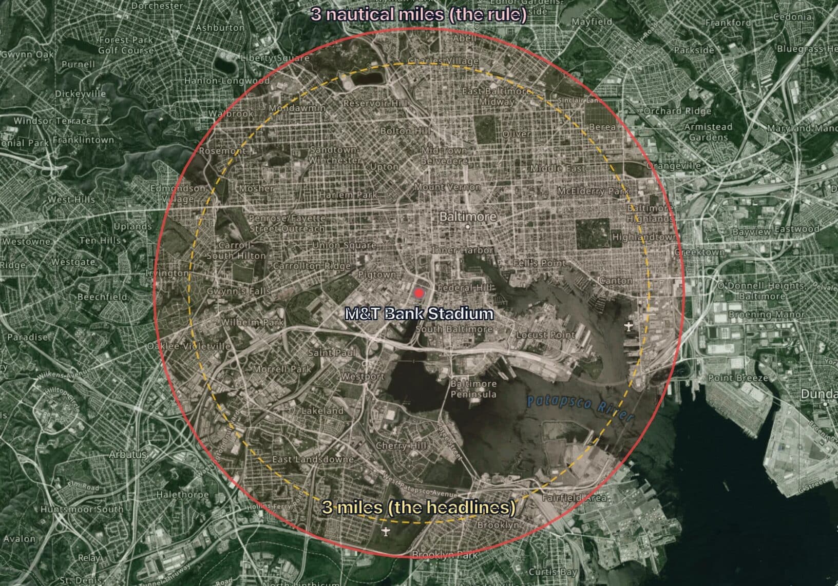
The app will not stop you
Hebert expected the app to block the flight. Since January 13, 2025 DJI, the biggest consumer drone maker, no longer blocks flights into restricted US airspace at all. Its apps show the FAA data and a warning, and the decision belongs to the pilot. So on a game day, check the FAA's list of active flight restrictions, then put the ring on the map with your launch point and the flight you have in mind. A launch point outside the ring does not help if the flight crosses it.
For venue security, the pilot is a grid reference
A drone over the bowl is a ten-second problem for the command post and a ten-minute problem for whoever has to find the pilot. In 2024 the troopers did it by eye. Since March 16, 2024 every drone that must be registered with the FAA must also broadcast Remote ID, which includes the position of the controller, so a detection receiver now hands the command post a pair of coordinates instead of a direction to run in.
Paste the coordinates into the map search and they land in a cell of the venue's lettered grid, so the radio call is "operator in J2". Measure from the nearest post to that cell and send that post. The grid is the one from the security site plan, so nobody learns a new map in the middle of an incident. If the detection system exports its track as KML or GPX, import it and the flight path sits on the same grid.
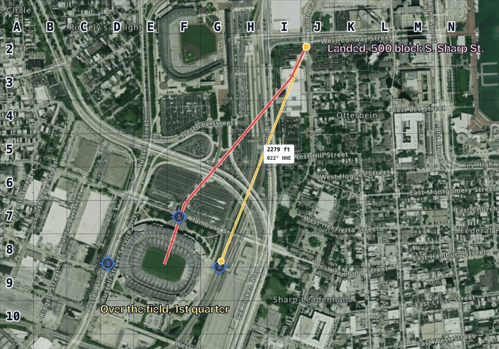
No broadcast, no coordinates. Sweep in sectors.
Remote ID does nothing against a home-built drone or one with the broadcast switched off. Then the question is where someone could stand with a view of the bowl, and the answer is every direction. Split the approaches into sectors and give each unit its own, so the parking lots, rooftops and side streets are each covered once. The mechanics are the same as dividing a search area into sectors. Do it before the season, then share a read-only link with every unit before the gates open. On the plan below, the 2024 pilot would have landed in C1, in Unit 2's part of the sweep.
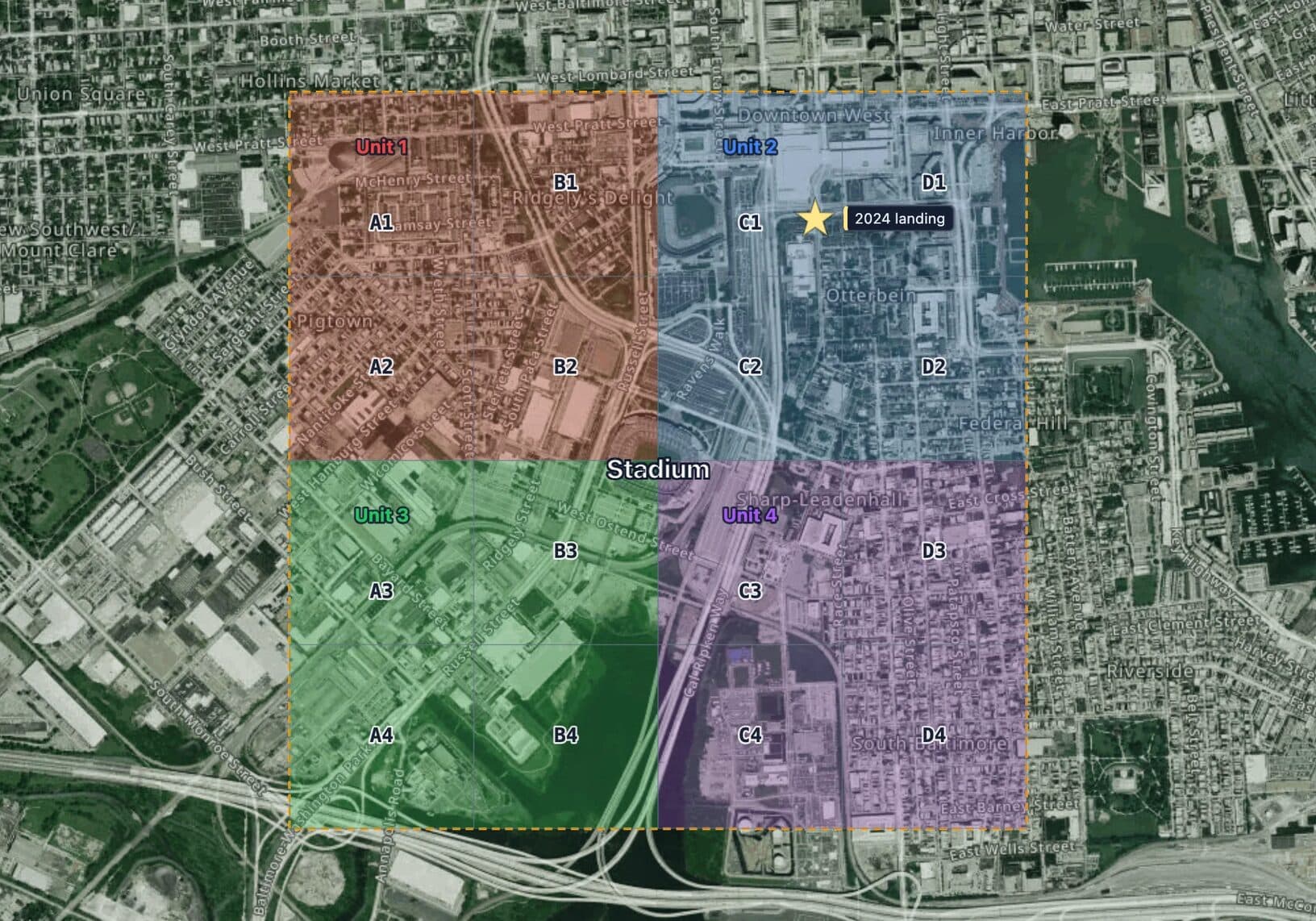
Do it for your stadium
- Search the stadium and center a radius ring on it at 5.56 km.
- Flying for fun? Mark your launch point and the flight. If either touches the ring on a game day, fly another day.
- Running security? Add a lettered 100 metre grid, number the posts and split the approaches into sectors.
- Share the read-only link with every unit before kickoff.
Then take the map to the field. Export it as a geospatial PDF and open it in an offline map app on the phone next to your controller. Your GPS dot moves across the same ring, grid and sectors, so a pilot sees how far from the line they stand and a post sees which sector they are in. It needs no signal, which is useful in a stadium full of phones.
FAQ
How big is the drone no-fly zone around a stadium?
3 nautical miles (5.56 km, or 3.45 statute miles) from the stadium, from the ground up to 3,000 feet, starting one hour before the scheduled start and ending one hour after the event ends. It applies to stadiums with 30,000 or more seats hosting a regular season or postseason NFL, MLB or NCAA Division I football game, and to major NASCAR and IndyCar races. The source is the FAA's standing notice FDC NOTAM 4/3621.
Can I fly a drone near a stadium when there is no game?
The sporting event restriction only exists during those game windows. Outside them the ordinary airspace rules apply, and many stadiums sit in controlled airspace near an airport, so check the FAA's airspace data for the spot before you fly.
What happens if you fly a drone over a stadium during a game?
The FAA classifies the zone as national defense airspace, so a knowing violation is a federal crime. Both Baltimore pilots were identified, charged federally, pleaded guilty and were sentenced to probation and a $500 fine, one of them with 100 hours of community service.
Is MapGridder free for stadium and event security teams?
Personal and non-commercial use is free; commercial use needs a paid license. A venue security team or a security contractor planning for a client is commercial use. Contact sales@mapgridder.com for a team license or a self-hosted deployment.
The rule is a circle. Draw it the right size. Open the map and put the ring on your stadium.
Venue security teams and contractors plan on this map under a commercial license, on our servers or self-hosted. Write to sales@mapgridder.com.