Four Guys, One Ladder, Zero Private Dirt: The Corner Crossing Story
September 10, 2026
Somewhere in Wyoming there is a stepladder that beat a pharmaceutical fortune in federal court. This is the story of that ladder, the four Missouri hunters who carried it, the square-mile board game the railroads left behind in 1862, and why the whole thing is now a map problem you can solve from your couch.
The short version
- Chunks of the West are a checkerboard: public square, private square, public square. Millions of public acres touch other public acres only at a corner.
- Four hunters stepped corner to corner on a ranch near Elk Mountain, Wyoming, using a ladder so their boots never touched private ground. The ranch sued for seven figures.
- A jury, a district judge and the Tenth Circuit all landed in the same place: that is not trespass. The Supreme Court declined to touch it, so that is where it stands.
- None of it helps you unless you can see the corners. MapGridder now draws public land by owner, so the corner is a dot on your map instead of a guess in the sagebrush.
First, why Wyoming looks like a chessboard
In 1862 Congress wanted a railroad to the Pacific and had no cash, so it paid in dirt. The railroad got every odd-numbered square mile in a strip along the tracks; the government kept the even ones. Nobody expected people to want the government squares. Then people did, the railroad sold its squares to ranches, and a century and a half later the West still has a checkerboard baked into it. Zoom out on the map and it looks like somebody spilled a board game across Carbon County.
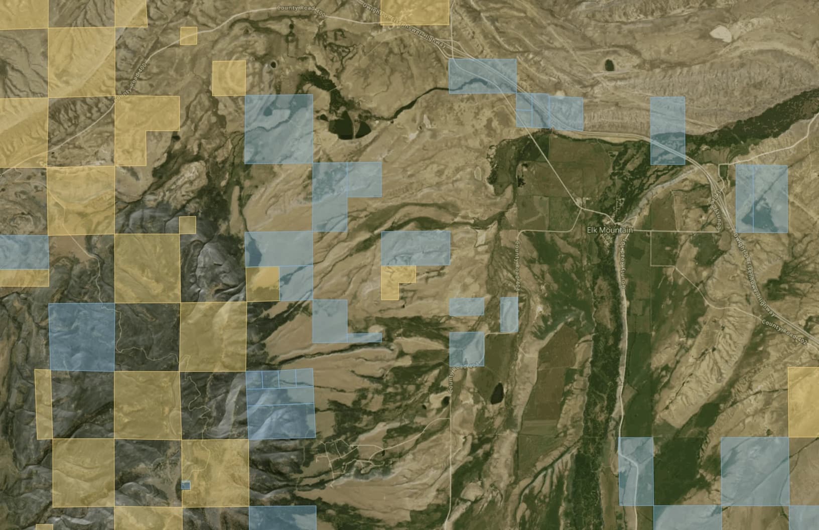
Here is the catch. Two public squares that sit diagonally touch at exactly one point, a survey corner with no width at all. Step across it and for a fraction of a second you are hovering over the two private squares on the other diagonal. Ranchers have spent decades saying that is trespass, which turns their private squares into a moat and the public squares behind them into a private hunting preserve nobody paid for.
The play
Fall 2020. Brad Cape, Zach Smith and Phillip Yeomans drive out from Missouri to chase elk on the BLM squares inside Elk Mountain Ranch, a 22,000 acre spread owned by Fred Eshelman, a pharma founder with a Forbes-page kind of bank account. They walk corner to corner. The ranch manager is not thrilled. In 2021 they come back with a fourth guy, John Slowensky, and this time they bring a ladder. An A-frame stepladder. The ranch had planted a signpost on each of its two squares and strung a chain between them straight across the corner. The hunters set the ladder up over the chain, climbed it, and came down on the public square on the far side. Not one bootprint on private ground.
The ranch called the sheriff anyway. Carbon County charged the four with criminal trespass. In April 2022 a local jury looked at the ladder and said not guilty. So the ranch went civil and sued for somewhere between seven and nine million dollars, on the theory that strangers being able to reach the public land inside the ranch made the ranch worth less. Read that twice. Strip out the lawyer words and the claim was that the ranch had been enjoying a private elk preserve built out of public squares, and a ladder from a hardware store had ended the arrangement.
The ref's call
The hunters' whole defense fit on a bumper sticker: a law from 1885. The Unlawful Inclosures Act says you cannot fence the public out of public land, and that was written when cattle barons were stringing barbed wire around government range like they owned it. In May 2023 Chief Judge Scott Skavdahl sided with the ladder: a chain strung across a corner is the 1885 problem in a new outfit, and a hunter whose boots stayed on public ground owed the ranch nothing.
The ranch appealed. On March 18, 2025 the Tenth Circuit backed him up and went a step further. Under Wyoming law the hop might technically be a trespass, the court said, but the federal act wins, and a landowner does not need a single strand of wire to break it; signs and a lawyer are enough to build what the court called a virtual wall. The ranch asked the Supreme Court to weigh in. On October 20, 2025 the Supreme Court said no thanks, which settles nothing about the merits and everything about the outcome. Game over, at least in the Tenth Circuit: Wyoming, Colorado, Utah, New Mexico, Kansas and Oklahoma, roughly 3.3 million acres of corner-locked public land now reachable on foot. Montana, Idaho and the rest of the Ninth Circuit have no ruling of their own, so the legal part out there is on you.
Cool. Now where is the corner?
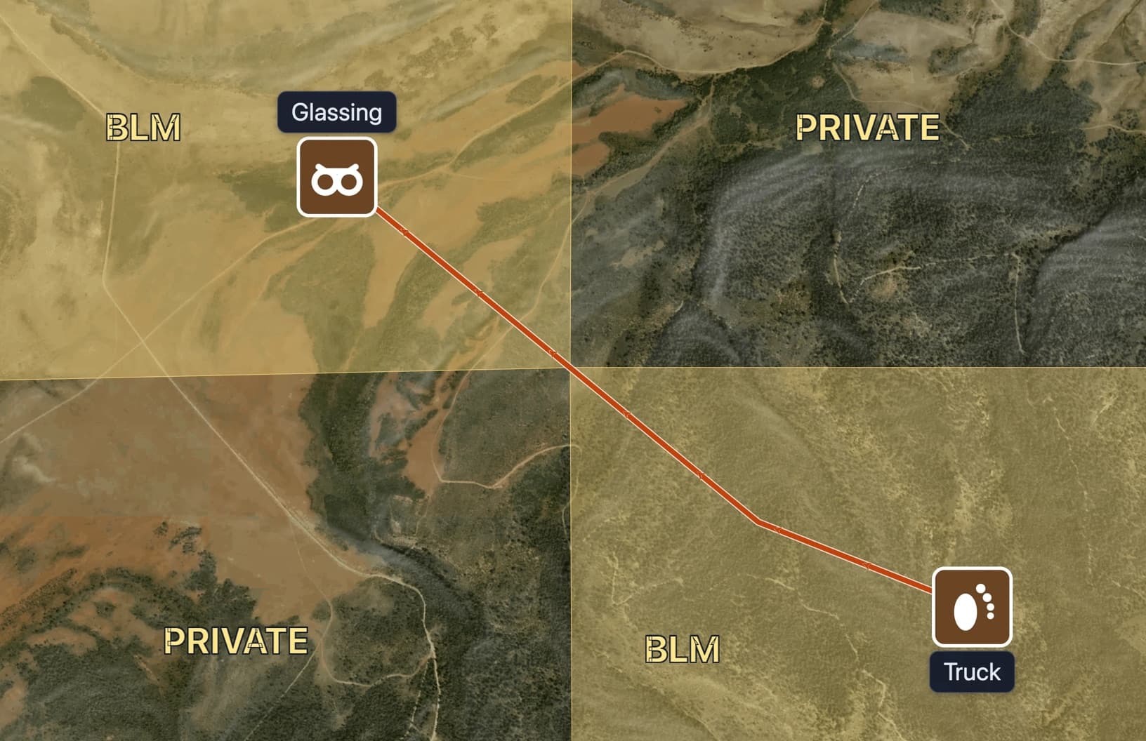
This is the part every celebratory article skipped. The ruling gives you a corner that is one point wide, surrounded by land where a landowner would very much like to meet you. You do not get to eyeball it. You need the boundary, the manager, and the corner on the same screen as your truck, your route and your glassing spot, before you leave the driveway.
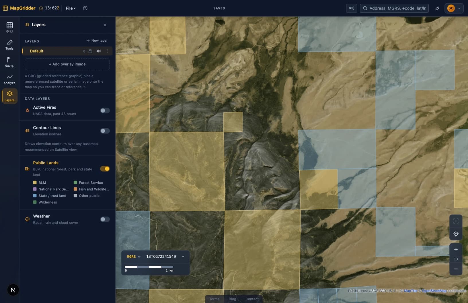
That is why MapGridder has a Public Lands layer now. Turn it on and every public parcel in the country gets a color by who runs it: BLM, Forest Service, National Park, Fish and Wildlife, state trust, other public, plus an outline around designated wilderness. Private land stays blank. The data is the USGS PAD-US 4.1 inventory, the same federal dataset the agencies publish their own boundaries from, cut into a map layer that works on any basemap. Satellite for the timber, topo for the ridgelines, same yellow squares on both.
A hunt plan that never touches white
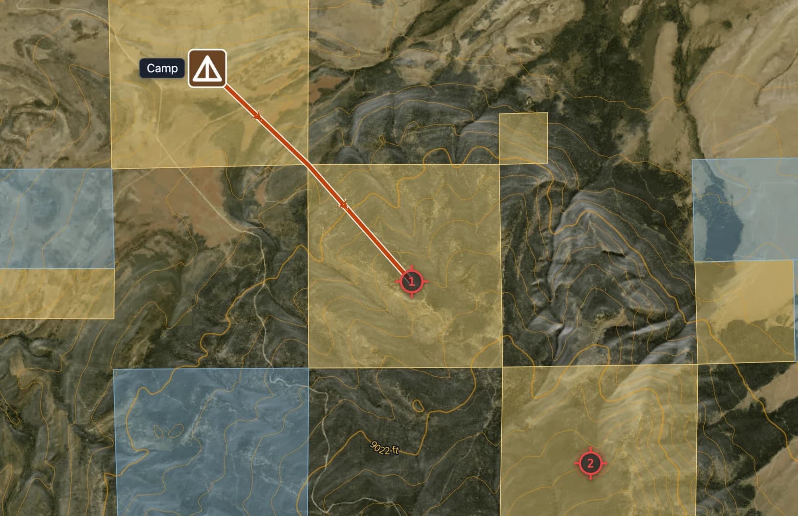
Once the squares are on screen the plan draws itself. Park on a public square that touches a road. Camp on a public square. Route to the glassing point through public squares only, corners where you must, and mark the two spots you want to be at first light. Add contour lines so the route goes around the mountain instead of over it. Then export the whole thing as a geospatial PDF and your phone shows your blue dot on those same squares with no signal, which in Carbon County is most of the time.
One honest note before you pack the ladder. A map layer is a planning tool, not a survey. The real corner is a brass cap in the dirt, and the parcel lines on any map, ours included, are drawn from the agencies' GIS data, not from that cap. Find the pin, know your state, and then enjoy land you have owned the whole time.
Do it yourself in five minutes
- Open the map, search your unit or the nearest town, and switch to the satellite basemap.
- Turn on Public Lands under Layers. Yellow is BLM, green is Forest Service, blue is state, blank is somebody's ranch.
- Find the corner where two public squares touch, and drop a waypoint on it.
- Draw the route from the truck through the corner to where you want to glass, and add contour lines.
- Export a geospatial PDF or a print, and take the same picture into the field.
FAQ
Is corner crossing legal?
In the Tenth Circuit (Wyoming, Colorado, Utah, New Mexico, Kansas and Oklahoma) the 2025 appeals ruling in Iron Bar Holdings v. Cape held that the Unlawful Inclosures Act of 1885 protects a hunter who steps corner to corner between public parcels without setting foot on or damaging the private ones, even where state trespass law would otherwise apply. The Supreme Court declined to review the case in October 2025. Elsewhere the question is still open, so check your state before you hop.
Does MapGridder include a BLM data layer?
Yes. The Public Lands layer covers the whole United States: BLM, Forest Service, National Park, Fish and Wildlife, state trust and other public parcels each get their own color, designated wilderness is outlined, and private land stays unshaded. The data is the USGS PAD-US 4.1 inventory, and the layer works on the satellite, topo and street basemaps.
Can I export the public land map as a PDF?
Yes. The layer is drawn into the map itself, so every export includes it: a real-scale PDF for printing, an image, or a geospatial PDF that opens in an offline map app with your GPS position on the same parcels. Exports need a free account.
Is the public lands map free?
Commercial use needs a paid license.
The ladder did its part. Yours is finding the corner. Open the map, turn on Public Lands, and go look at what you own.